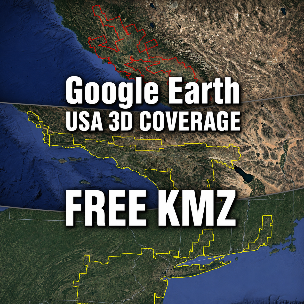
Would you like to see exactly where Google Earth’s photorealistic 3D imagery begins and ends?
This page provides free KMZ boundary files for Google Earth 3D coverage areas across the United States.
Load a file into Google Earth Pro and you can follow the real outline of each 3D region, zoom into narrow sections and see how cities, suburbs, farmland, mountains and coastlines fit within the coverage.
The files currently available include New York, San Francisco and Los Angeles. More U.S. cities and regions will be added as our surveys continue.
Google Earth’s 3D coverage changes over time. When we confirm that an area has expanded or changed, we will retrace the boundary and replace the KMZ with an updated version.
Free and independently researched: These KMZ files were manually created by Global Map Insights, an independent website based in Japan. They are not official Google coverage files.
On this page
- Free U.S. Google Earth 3D coverage KMZ downloads
- New York 3D coverage
- San Francisco 3D coverage
- Los Angeles 3D coverage
- How to open a KMZ file
- How the boundaries are surveyed
- Update policy and future additions
Free U.S. Google Earth 3D Coverage KMZ Library
Google Earth allows us to explore many American cities in detailed photorealistic 3D. However, the coverage often extends far beyond the city named on the map.
New York’s 3D region crosses several state lines. San Francisco’s coverage stretches across a large part of northern and central California. Los Angeles includes an extensive continuous region as well as several separate 3D zones.
Google does not publish these exact regional outlines as downloadable KMZ files. To make the boundaries easier to understand, we checked them in Google Earth Pro and traced the transition between photorealistic 3D imagery and surrounding 2D imagery.
The resulting files can be downloaded below and opened directly in Google Earth Pro.
| 3D coverage region | Boundary length | Measured area | Survey date |
|---|---|---|---|
| San Francisco | Approx. 3,858 km 2,397 miles |
Approx. 65,590 km² 25,325 sq mi |
March 2026 |
| New York | Approx. 2,513 km 1,562 miles |
Approx. 55,922 km² 21,592 sq mi |
March 2026 |
| Los Angeles | Approx. 1,638 km 1,018 miles |
Approx. 28,217 km² 10,895 sq mi |
March 2026 |
The Los Angeles figures in this table refer to its largest continuous 3D coverage region. Several smaller independent 3D areas around Southern California are included in the downloadable Los Angeles KMZ package.
New York Google Earth 3D Coverage KMZ
Google Earth 3D View of New York City
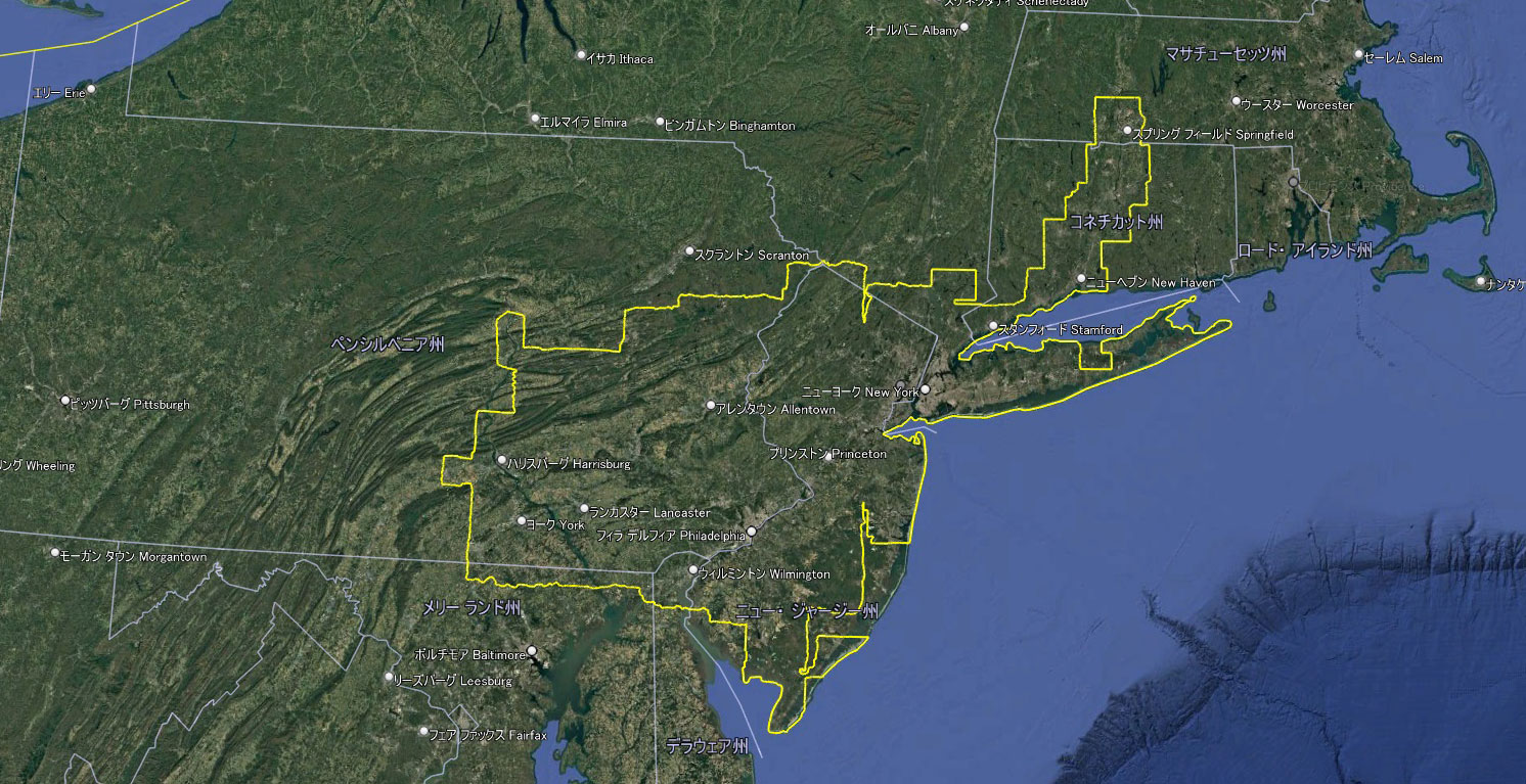
New York’s photorealistic 3D coverage is much larger than New York City alone.
The continuous region extends into New Jersey, Pennsylvania and Connecticut, covering a wide part of the northeastern United States.
The boundary measures approximately 2,513 km, or 1,562 miles. Its measured area is approximately 55,922 km², or 21,592 square miles.
New York 3D Coverage Boundary
- Format: KMZ
- Surveyed: March 2026
- Boundary length: approximately 2,513 km
- Area: approximately 55,922 km²
- Price: Free
San Francisco Google Earth 3D Coverage KMZ
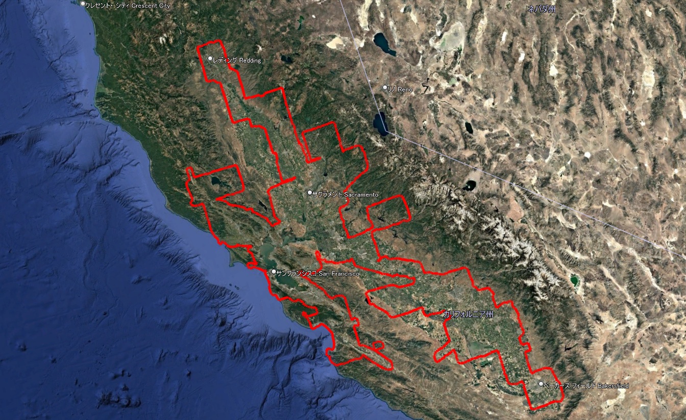
The San Francisco 3D region covers a surprisingly large part of California.
It extends from near Redding in the north to the Bakersfield area in the south. The coverage includes San Francisco, Oakland, San Jose, Sacramento, Stockton, Modesto, Fresno and many other cities and landscapes.
The boundary measures approximately 3,858 km, or 2,397 miles. Its measured area is approximately 65,590 km², or 25,325 square miles.
San Francisco 3D Coverage Boundary
- Format: KMZ
- Surveyed: March 2026
- Boundary length: approximately 3,858 km
- Area: approximately 65,590 km²
- Price: Free
Nearby National Parks 3D Coverage KMZ
A separate KMZ is also available for 3D coverage areas around national parks near the main San Francisco region.
Nearby National Parks 3D Lines
Use this additional file to view the separate 3D boundaries around nearby national park areas.
Los Angeles Google Earth 3D Coverage KMZ
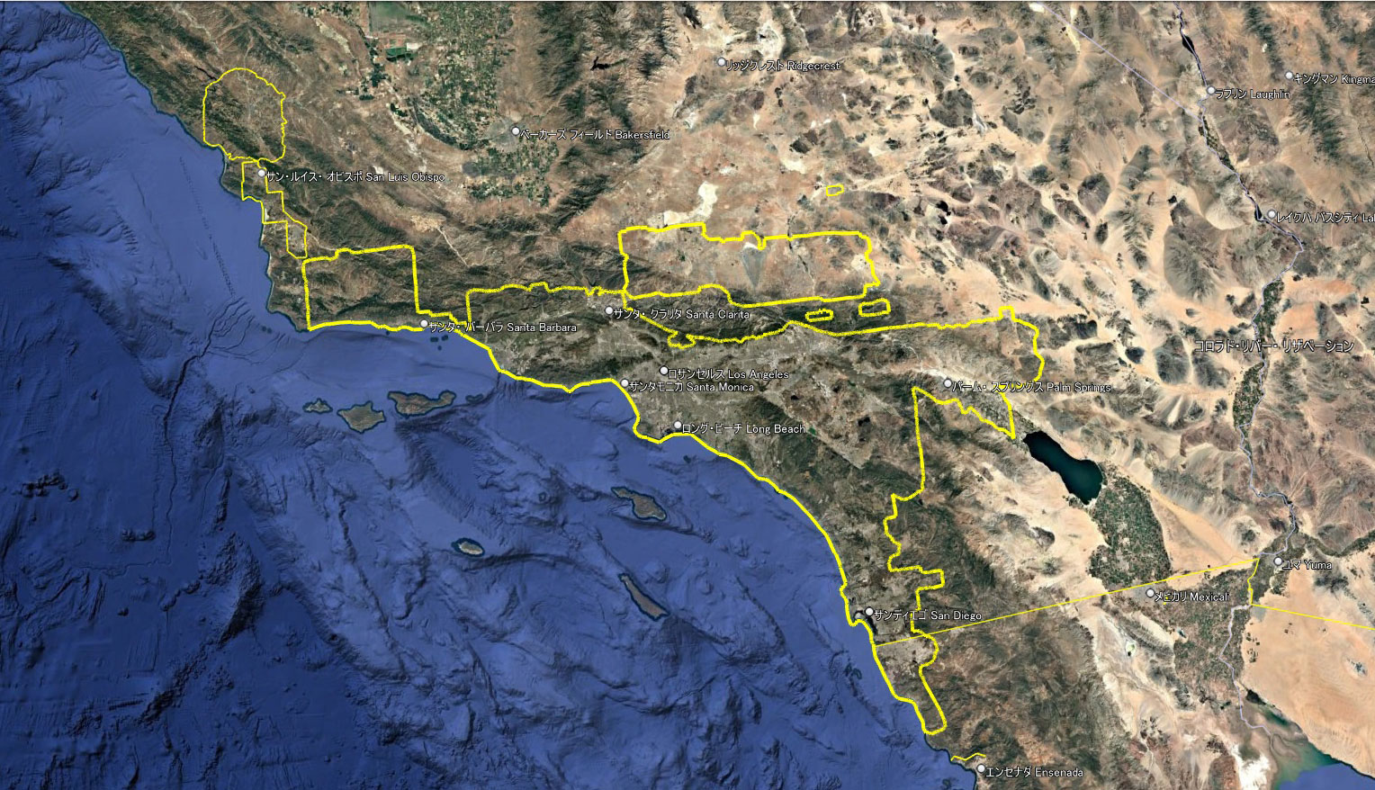
Several additional 3D coverage zones surrounding the Los Angeles 3D area
Los Angeles has a broad continuous 3D region covering the metropolitan area, surrounding cities, mountains, forests and desert-side communities.
The largest continuous region measures approximately 1,638 km, or 1,018 miles, around its boundary. Its measured area is approximately 28,217 km², or 10,895 square miles.
The downloadable package also includes smaller independent 3D areas around Southern California.
Los Angeles 3D Coverage Boundaries
- Format: KMZ
- Surveyed: March 2026
- Main boundary length: approximately 1,638 km
- Main continuous area: approximately 28,217 km²
- Includes surrounding independent 3D zones
- Price: Free
How to Open a KMZ File in Google Earth
You do not need specialist GIS software to use these files. Google Earth Pro can open them directly.
- Select the KMZ download button for the region you want to explore.
- Google Drive will open in a new tab.
- Select the download icon.
- Save the KMZ file to your computer.
- Open Google Earth Pro.
- Select File and then Open.
- Choose the downloaded KMZ file.
- Use the Places panel to turn the boundary lines on or off.
Google Drive may display “No preview available” because it cannot preview KMZ files in the browser. This does not mean that the file is damaged. Download it and open it with Google Earth Pro.
What Can You Do With These KMZ Files?
Once the boundary is loaded, you can explore the coverage in many different ways.
- See where photorealistic 3D imagery begins and ends
- Compare 3D and 2D areas
- Follow narrow sections between cities
- Check whether mountains, forests and farmland are included
- Compare current coverage with older maps
- Study the scale and shape of different U.S. 3D regions
- Keep a dated record of Google Earth coverage
The files are especially useful for Google Earth enthusiasts, geography students, researchers, map creators and anyone interested in the development of photorealistic 3D mapping.
How We Survey Google Earth 3D Coverage
These boundaries are not produced automatically.
We open Google Earth Pro and inspect the visible transition between photorealistic 3D imagery and the surrounding 2D surface. The boundary is then followed and traced by hand.
After the line is complete, we check the connections, close the outer boundary and calculate its total length and enclosed area from the KMZ coordinates.
Because Google Earth’s 3D coverage does not follow state, county or city limits, the resulting boundaries often have many turns, narrow corridors and separate sections.
The boundaries are approximate. Small differences may occur depending on display conditions, imagery loading and later Google Earth updates.
KMZ Files Will Be Updated When Coverage Expands
Google Earth’s 3D imagery continues to change. Separate city areas may grow, narrow gaps may be filled and previously independent regions may become connected.
We will continue checking the published regions. When a clear expansion or boundary change is confirmed, the affected KMZ will be retraced and updated.
Each file name and download section will show the survey date so that users can identify the version they are viewing.
| Update status | What we will do |
|---|---|
| Small display fluctuation | Continue observing before changing the file |
| Clear boundary expansion | Retrace and publish an updated KMZ |
| Separate 3D areas become connected | Rebuild the regional boundary |
| New major U.S. region surveyed | Add a new download section to this library |
Bookmark this page if you would like to check for future versions and newly added U.S. cities.
More U.S. Cities and Regions Will Be Added
This library begins with New York, San Francisco and Los Angeles, but it is not limited to these three regions.
Future additions may include other major U.S. cities and large continuous 3D coverage areas as our surveys are completed.
Rather than publishing a simple list of city names, we aim to provide useful boundary files that users can open, inspect and compare for themselves.
Terms and Important Information
- These files are independently traced research data.
- They are not official Google files.
- Global Map Insights is not affiliated with or endorsed by Google.
- The files do not contain Google satellite imagery.
- Google Earth is required to view the underlying 3D imagery.
- The boundaries may change as Google updates its services.
- The files should not be used for navigation, surveying, property boundaries or safety-critical decisions.
The KMZ files are provided free of charge. If you would like to introduce them on another website or social media account, please link to this download library or the relevant research article instead of uploading and redistributing the files.
About Global Map Insights
Global Map Insights is an independent website based in Japan.
We study Google Earth 3D and 2D coverage in Japan, the United States and other parts of the world. Our goal is to record how digital maps change and make difficult-to-see geographic boundaries easier to explore.
This U.S. KMZ library will continue to grow as new surveys and updates are completed.
References
Google Earth
Google Earth Blog: Google Earth Automatically Generated 3D Areas
Google Earth Blog: New Google Earth Layers – 3D Cities
Google Developers: KMZ Files
Last updated: July 2026. Current KMZ coverage: New York, San Francisco, Los Angeles and nearby national park areas in California.
コメント