How far does the Los Angeles 3D coverage map extend in Google Earth?
The extent of Google Earth 3D coverage varies significantly depending on the city and region.
In this article, following our detailed New York 3D coverage analysis, we examine the full scope of the Los Angeles (LA) 3D coverage map, including Google Earth 3D buildings, urban areas, suburbs, and surrounding natural landscapes.
In conclusion, the Los Angeles 3D coverage in Google Earth extends far beyond the core metropolitan boundaries, continuously connecting the city center with surrounding cities, residential zones, and large-scale geographic features.
The scale of Google Earth 3D in Los Angeles goes well beyond the typical expectations of a single-city 3D map, offering a wide and highly detailed 3D visualization of the entire LA region.
SECTION ①:Los Angeles (LA) 3D coverage – How far does it extend?
In this section, we examine the overall extent of Los Angeles (LA) 3D coverage in Google Earth, focusing on how far the 3D mapping area expands beyond the city center. By analyzing both urban and surrounding regions, we can understand the true scale of LA’s 3D coverage before breaking down each specific area in detail below.
LA 3D coverage area overview / Los Angeles 3D coverage area overview
This map shows the extent of Google Earth 3D coverage across the Los Angeles region, highlighting how urban areas, surrounding cities, desert-side zones, and mountain resort regions are continuously connected into a large-scale 3D environment.
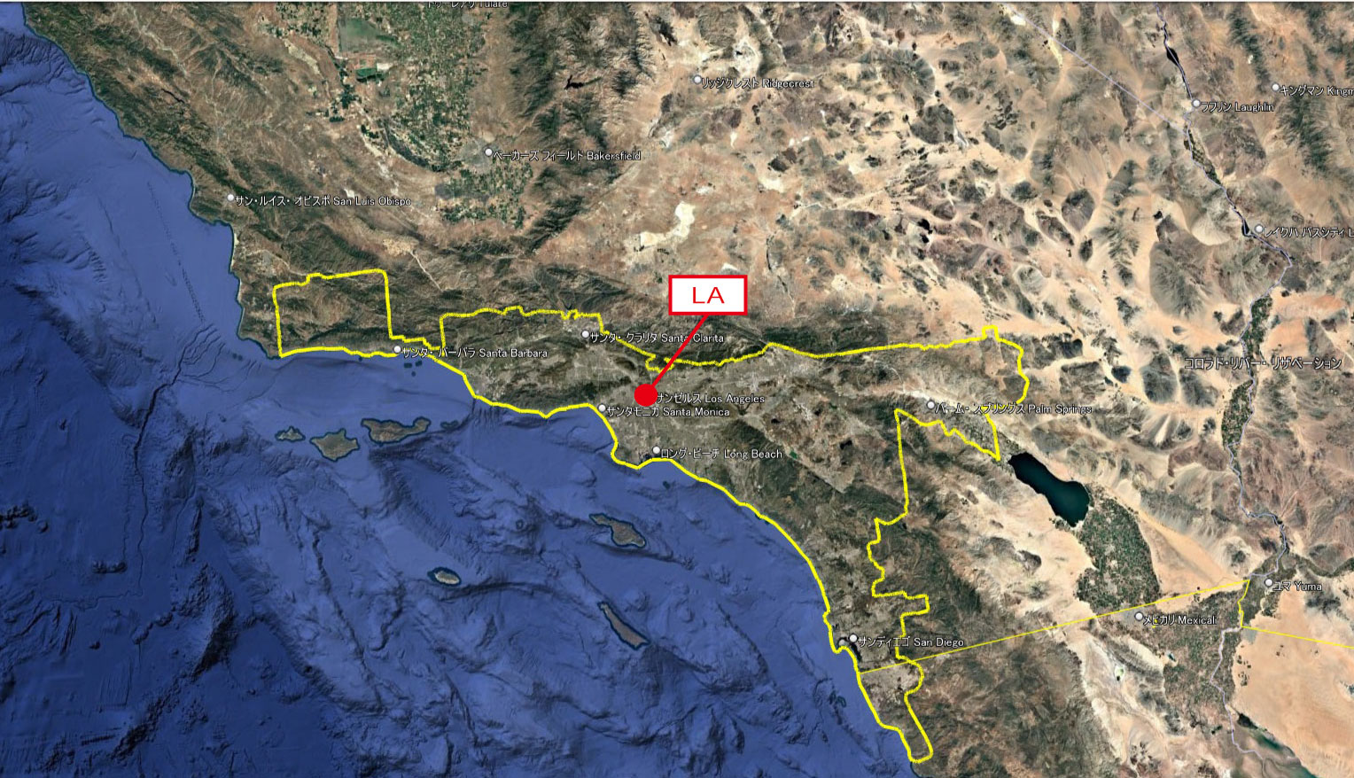
google earth 3d coverage los angeles map
Upon closer examination, the 3D coverage area of Los Angeles extends far beyond the boundaries of the metropolitan region.
It not only includes the urban core of Los Angeles and its surrounding metropolitan areas, but also continuously covers natural landscapes such as mountain ranges, deserts, and forests located between cities—all rendered seamlessly in 3D in Google Earth.
This coverage spans approximately 290 km (180 miles) vertically and 430 km (267 miles) horizontally, extending across a vast region that even reaches the southern border with Mexico.
Rather than being limited to a single urban cluster, it is clear that this is a broad and continuous regional-scale 3D coverage in Google Earth.
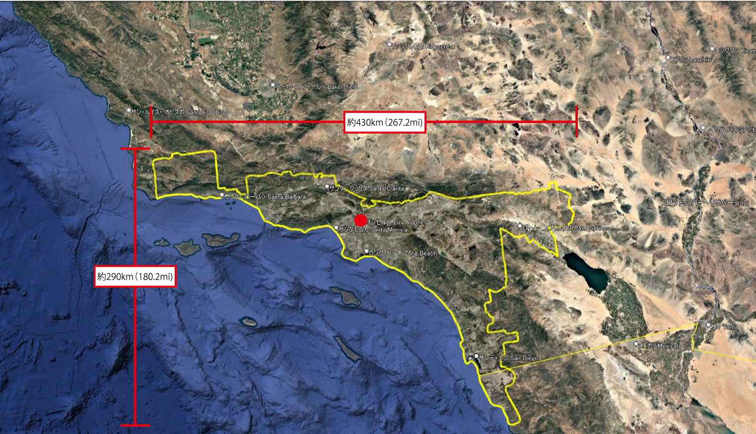
Distance of the Los Angeles 3D coverage area
Surrounding independent 3D coverage areas
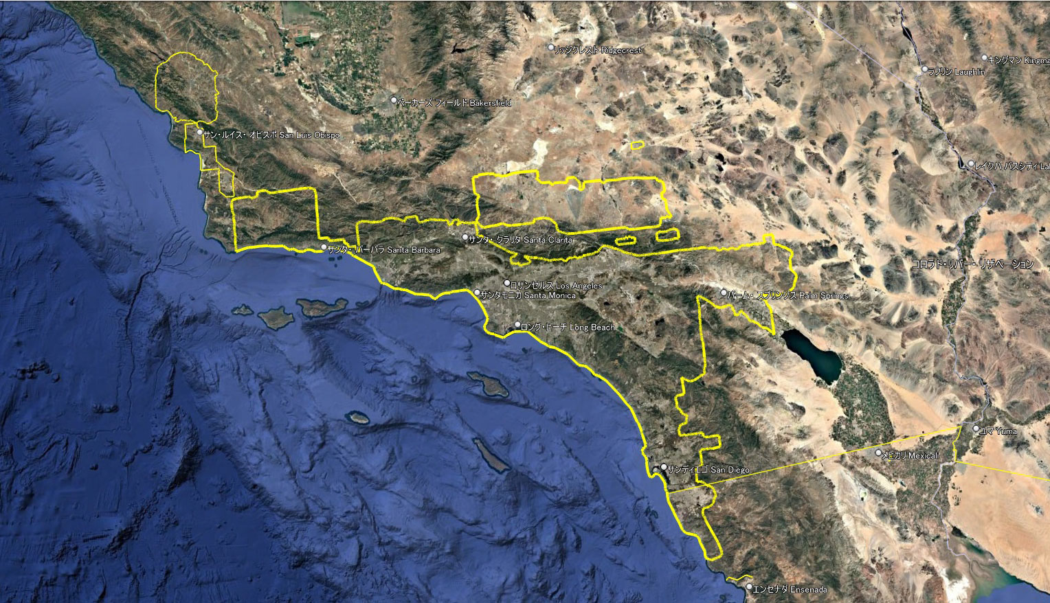
Several additional 3D coverage zones surrounding the Los Angeles 3D area
However, in reality, there are multiple independent 3D coverage zones distributed around the Los Angeles region.
These include not only coastal cities and inland urban areas, but also mountain resort regions and other geographically distinct zones.
In the following section, we will introduce the main locations included within each of these surrounding 3D coverage areas.
Distance and Cities Included in Each 3D Coverage Area
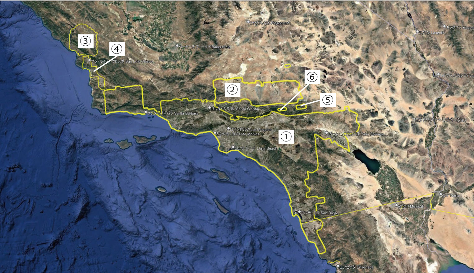
Distance and Cities Included in Each 3D Coverage Area
Here, “distance” refers to the total length of the 3D coverage line.
| Area | Distance (km) |
Distance (mi) |
Major Cities and Locations Included in the Area |
| ① | 1,638 | 1,018 |
Los Angeles County, CA Orange County, CA Riverside County, CA San Bernardino County, CA |
| ② | 421 | 262 | Urban areas on the desert region side
Los Angeles County, CA San Bernardino County, CA |
| ③ | 202 | 126 | San Luis Obispo County, CA Paso Robles, CA Templeton, CA Atascadero, CA |
| ④ | 181 | 113 | San Luis Obispo County, CA San Luis Obispo, CA Arroyo Grande, CA Santa Maria, CA |
| ⑤ | 48 | 30 | Southern California Mountain Resort Areas
San Bernardino County, CA |
| ⑥ | 40 | 25 | Core Mountain Resort Areas
Lake Gregory |
SECTION ②: Comparison with Other Cities
Los Angeles (standalone): 1,638 km (1,018 mi)
New York: 2,516 km (1,536 mi)
Tokyo metropolitan area: 1,300 km (808 mi)
The 3D coverage area of New York is approximately 900 km (560 mi) longer than that of Los Angeles when comparing standalone city coverage.
However, when the five surrounding 3D coverage zones are included in the Los Angeles system, the total extent reaches approximately 2,530 km (1,572 mi), making it comparable in scale to New York’s overall 3D coverage area.
SECTION ③: Comparison with Data from 2017
The previous section illustrated the current wide-area 3D coverage around Los Angeles, along with six additional scattered 3D coverage zones in the surrounding region.
Here, we can compare historical data by overlaying the 3D coverage map published on the Google Earth Blog in 2017 with the current 3D coverage extent.
Initially, 3D coverage was limited mainly to urban areas. However, it has since expanded significantly, with previously separate zones now becoming interconnected.
In addition, the coverage has extended beyond urban centers into mountainous regions and desert landscapes, forming a massive continuous 3D coverage area spanning approximately 1,638 km (1,018 mi).
At present, outside this 1,638 km core coverage zone, there are five additional independent 3D coverage areas. Some of these regions may merge in the near future as coverage continues to expand.
Furthermore, there is a possibility that the expanding San Francisco (SF) 3D coverage area could eventually connect with the Los Angeles region, creating an even larger continuous West Coast 3D network.
LA KML Data Download
Would you like to experience the vast Los Angeles 3D coverage area directly in Google Earth Pro?
By downloading the KMZ data that includes Areas ①–⑥, you can reproduce and explore the exact 3D coverage presented in this article.
Download for free
https://drive.google.com/file/d/1xO86YkpW-x5btME7pbgsr4Fqh6KzoU_T/view?usp=drive_link
Download the Los Angeles 3D coverage KMZ data and explore it directly in Google Earth Pro.
The file includes Areas ①–⑥, allowing you to fully reproduce and experience the 3D coverage illustrated in this article.
This dataset visualizes the detailed Google Earth 3D coverage of the Los Angeles region.
Download the KMZ file and explore the full 3D coverage yourself in Google Earth.

コメント