For first-time visitors to Global Map Insights
When you explore a city in Google Earth, some areas appear in photorealistic 3D, with buildings and terrain reproduced as three-dimensional models.
However, simply viewing a city in Google Earth does not always make it easy to tell where the 3D coverage ends and the standard 2D imagery begins.
At Global Map Insights, we independently examine the boundaries between Google Earth’s photorealistic 3D and 2D areas. We then create “3D Coverage Tours” that follow these boundaries from the air.
Following our first tour of Hirosaki in Aomori Prefecture, this second installment explores the Google Earth 3D coverage area of Kushiro, Hokkaido, through a video tour and overview maps.
For returning readers
Boundary paths are valuable resources for understanding and comparing the extent of Google Earth’s 3D coverage.
This time, we travel around the 3D coverage area of Kushiro, a major city in eastern Hokkaido known for its port and coastal landscape.
We hope you will enjoy this video not only as geographic reference material, but also as a virtual flight around the area currently covered by Google Earth’s photorealistic 3D data.
Google Earth Kushiro 3D Coverage Tour
This video follows the boundary of Google Earth’s 3D coverage area in Kushiro, Hokkaido.
The tour completes a circuit of the approximately 51.3-kilometer (31.9-mile) boundary in about 76 seconds.
The flight follows the yellow boundary line clockwise, showing where Google Earth’s photorealistic 3D coverage transitions into standard 2D imagery.
If the video does not appear, search for “Global Map Insights” on YouTube.
What Does the Yellow Line in the Video Represent?
The yellow line shown in the video marks the boundary between Google Earth’s photorealistic 3D coverage and its standard 2D imagery.
- Yellow line: Boundary of the 3D coverage area
- Right side of the flight path: Photorealistic 3D coverage
- Left side of the flight path: Standard 2D imagery
- Direction of travel: Clockwise
By comparing the right and left sides of the screen, you can see the difference between areas where buildings are represented as three-dimensional models and areas where aerial imagery remains relatively flat.
The mini-map also shows the complete shape of Kushiro’s 3D coverage area and the aircraft’s current position during the tour.
Overview Map of Kushiro’s 3D Coverage Area
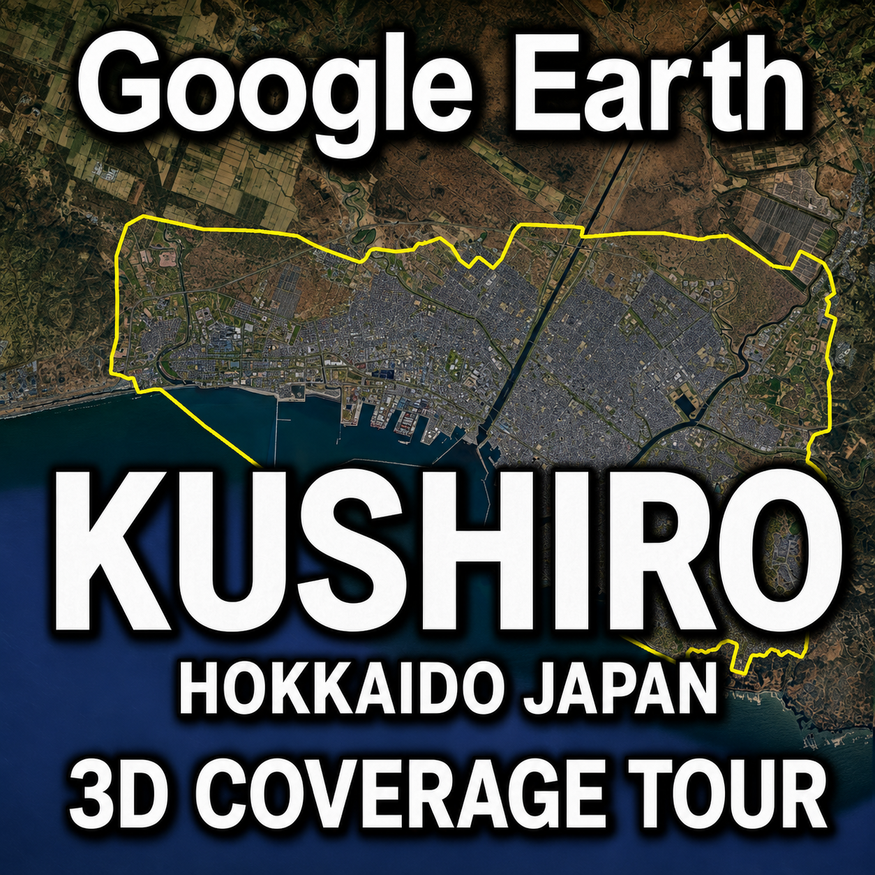
The following images show the overall extent of Kushiro’s 3D coverage area as observed in Google Earth.

Overview of Kushiro City and Kushiro Port in Google Earth

Yellow boundary line of the Google Earth 3D coverage area in Kushiro
Kushiro’s photorealistic 3D coverage in Google Earth. The yellow line marks the boundary of the 3D area.
Google Earth’s 3D coverage does not match the administrative boundaries of Kushiro City.
The entire municipality has not been converted into photorealistic 3D. Instead, coverage is concentrated around central Kushiro, Kushiro Port and the surrounding urban area.
The overview maps show that the 3D area follows the general shape of the coastline and the spread of the built-up area.
Kushiro has an extensive administrative area that includes part of the Kushiro Wetlands, but this entire region is not covered by photorealistic 3D.
The yellow line therefore represents the edge of Google Earth’s 3D data—not Kushiro’s official city boundary.
What Is Included in Kushiro’s 3D Coverage Area?
Kushiro’s 3D coverage is centered on the urban area and the surroundings of Kushiro Port.
From above, the area reveals many features that characterize the city, including port facilities, urban districts, rivers and the coastline.
One particularly interesting feature is that the boundary on the coastal side does not remain entirely over land.
In some places, it extends across the water according to the limits of Google Earth’s 3D data capture area.
As a result, Kushiro’s 3D coverage has a shape unique to Google Earth, rather than one based on a sightseeing route or administrative boundary.
What Is Photorealistic 3D in Google Earth?
Google Earth’s photorealistic 3D imagery uses three-dimensional models created from aerial imagery and other visual data to reproduce buildings and terrain in a realistic form.
In supported cities, users can view building heights, roof shapes, roads, trees, port facilities and changes in terrain from many different angles.
Areas without photorealistic 3D coverage are generally displayed using terrain data and standard aerial or satellite imagery.
Because 3D and 2D areas can exist within the same city, following the boundary provides a clear way to visualize the current extent of Google Earth’s 3D data.
Why Follow the Boundary of a 3D Coverage Area?
Many Google Earth tour videos visit famous buildings, landmarks and tourist attractions.
Global Map Insights takes a different approach.
Instead of traveling from one attraction to another, our 3D Coverage Tours focus on where Google Earth’s photorealistic 3D data begins and where it ends.
Following the boundary offers several ways to explore and understand the data:
- Check whether your neighborhood is covered by photorealistic 3D
- Compare the size and shape of 3D coverage between cities
- Observe differences between urban and suburban areas
- Record future expansions and updates to Google Earth’s 3D data
- Explore overlooked areas around the edges of cities
- Examine 3D data boundaries around ports and coastlines
The Kushiro tour can therefore be used not only to view the city from above, but also as a visual record of Google Earth’s current data coverage.
Comparing the 3D Coverage Areas of Hirosaki and Kushiro
The first tour in this series explored Hirosaki, where the approximately 56.8-kilometer (35.3-mile) boundary was completed in about 75 seconds.
The Kushiro tour follows an approximately 51.3-kilometer (31.9-mile) boundary in about 76 seconds.
- Hirosaki: Approximately 56.8 km (35.3 miles) — about 75 seconds
- Kushiro: Approximately 51.3 km (31.9 miles) — about 76 seconds
Although Hirosaki’s boundary is approximately 5.5 kilometers longer, the two videos are almost the same length.
The shapes and surrounding landscapes are very different. Hirosaki’s coverage is centered on an inland urban area, while Kushiro’s coverage includes a port, coastline and sections of the Pacific Ocean.
Watch the Google Earth Hirosaki 3D Coverage Tour
Kushiro’s 3D Coverage May Change in the Future
Google Earth’s aerial imagery and 3D data may be added or updated at different times depending on the region.
Areas currently displayed in 2D may receive photorealistic 3D coverage in the future, while existing 3D areas may expand into surrounding districts.
This video and the overview maps record Kushiro’s 3D coverage as it appeared in Google Earth at the time of our survey.
If we identify a significant change in Kushiro’s 3D coverage, we plan to update the boundary data and produce a new tour video.
Explore More Google Earth 3D Coverage
Global Map Insights examines Google Earth’s 3D coverage in cities across Japan and around the world.
We are gradually publishing additional tour videos that follow the boundaries between photorealistic 3D coverage and standard 2D imagery.
- Google Earth Hirosaki 3D Coverage Tour
- Google Earth San Francisco 3D Coverage Map
- Google Earth New York 3D Coverage and Evolution
- Google Earth Los Angeles 3D Coverage Map
About Global Map Insights
Global Map Insights independently examines photorealistic 3D coverage, changes in cities and the boundaries of geographic data in Google Earth and Google Maps.
On our YouTube channel, we publish “3D Coverage Tours” that travel around the extent of Google Earth’s photorealistic 3D areas.
Watch the videos to discover whether your city is currently available in photorealistic 3D.
If there is a city or region you would like us to investigate, please leave a comment on our YouTube channel.
Watch Global Map Insights on YouTube
Summary
This article introduced the extent of Google Earth’s photorealistic 3D coverage in Kushiro through a boundary tour video and overview maps.
- The yellow line marks the boundary of Google Earth’s 3D coverage
- Photorealistic 3D coverage is on the right side of the flight path
- Standard 2D imagery is on the left side of the flight path
- The tour follows the boundary clockwise
- The approximately 51.3-kilometer boundary is completed in about 76 seconds
Google Earth’s 3D coverage does not follow administrative borders or official city boundaries.
In Kushiro, the coverage forms a distinctive area that includes the port, central urban districts, rivers and sections of the coastline.
Global Map Insights will continue examining the 3D coverage of cities around the world and recording the results through maps and video tours.

コメント