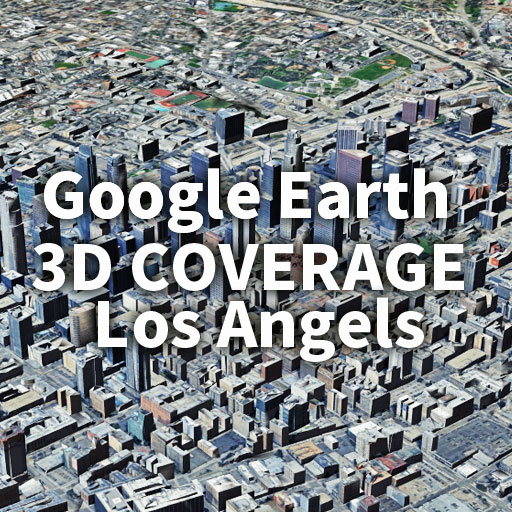
Los Angeles 3D coverageはどこまで広がるのか?
Google Earthの3D表示エリアは、都市によってその広がり方が大きく異なります。
本記事では、ニューヨークに続く検証第二弾として、ロサンゼルス(LA)の3D coverageの範囲を詳しく解説します。
結論から言うと、LAの3D表示は都市圏の枠を大きく超え、周辺都市や自然地形を含む広大なエリアに連続して広がっています。
そのスケールは、一般的な都市のイメージをはるかに超えるものです。
How far does Los Angeles 3D coverage extend?
The extent of 3D coverage in Google Earth varies significantly from city to city.In this article, as the second installment following New York, we take a closer look at the extent of 3D coverage in Los Angeles (LA).In conclusion, LA’s 3D coverage extends far beyond the boundaries of the metropolitan area, continuously spanning surrounding cities as well as natural landscapes.Its scale goes far beyond what is typically expected from a single urban area.
セクション①:Los Angeles 3D coverageはどこまで広がるのか?
LAの3D表示エリア/Los Angeles 3D coverage area overview
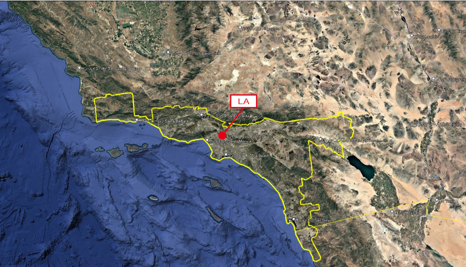
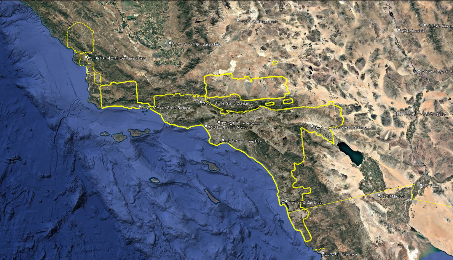
Google Earth 3D coverage around Los Angels
実際に確認してみると、LAの3D表示エリアは都市圏の範囲を大きく超えて広がっています。
ロサンゼルス市街地だけでなく、周辺の都市圏、さらに都市と都市の間に広がる山岳地帯や砂漠、森林といった自然地形までも、途切れることなく3Dで表示されています。
この表示エリアは、縦約290km(約180mi)、横約430km(約267mi)にも及び、南端はメキシコとの国境を越える広大な範囲に広がっています。
単なる都市の集合ではなく、広域的な3Dカバレッジであることが分かります。

Google Earth 3D coverage around Los Angels
Upon closer examination, the 3D coverage area of LA extends far beyond the boundaries of the metropolitan area.
Not only does it include the urban core of Los Angeles and its surrounding metropolitan regions, but it also continuously covers natural landscapes such as mountain ranges, deserts, and forests that lie between cities—all rendered seamlessly in 3D.
This coverage area spans approximately 290 km (180 miles) vertically and 430 km (267 miles) horizontally, extending over a vast region that even crosses the border into Mexico at its southern edge.
It is not merely a collection of cities, but a broad and continuous 3D coverage area.
周囲に存在する3D表示エリア

Google Earth 3D coverage around LA-2
LAの3D表示エリアは非常に広大です。
しかし実際には、その周囲には複数の独立した3D表示エリアが点在しています。これらは沿岸都市や内陸都市に加え、山岳リゾート地域なども含まれています。
次の項では、それぞれの3D表示エリアに含まれる主な地域をご紹介します。
The 3D coverage area of Los Angeles is extremely vast.
However, in reality, there are multiple independent 3D coverage areas scattered around it. These include not only coastal and inland cities, but also mountain resort regions.
In the next section, we will introduce the main areas included within each of these 3D coverage zones.
各3Dエリアの距離と含まれる都市
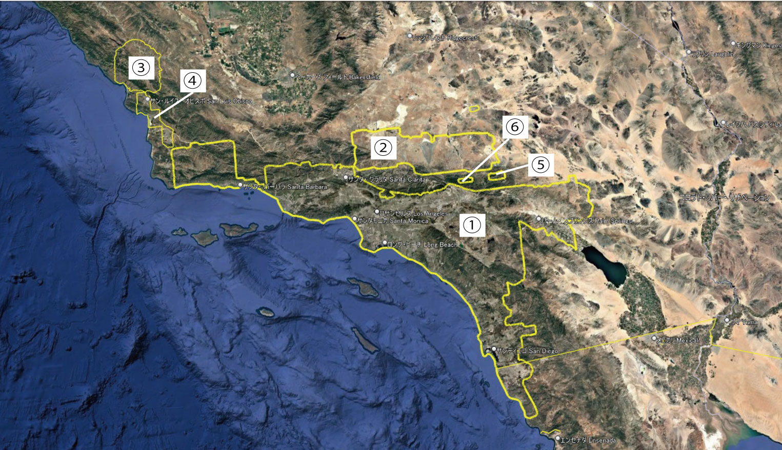
Google Earth 3D coverage around LA-3
| 距離 (km) |
距離 (mi) |
エリアに含まれる主な都市・地名 | |
| ① | 1,638 | 1,018 |
ロサンゼルス郡(Los Angeles County, CA)⇒ ロサンゼルス(Los Angeles, CA)、サンタモニカ(Santa Monica, CA)、パサデナ(Pasadena, CA)、ロングビーチ(Long Beach, CA)、グレンデール( Glendale, CA) オレンジ郡(Orange County, CA)⇒ アナハイム(Anaheim, CA)、アーバイン(Irvine, CA)、サンタアナ(Santa Ana, CA)、ハンティントンビーチ (Huntington Beach, CA) リバーサイド郡(Riverside County, CA)⇒ サンバーナーディーノ郡(San Bernardino County, CA)⇒ サンバーナーディーノ(San Bernardino, CA)、オンタリオ(Ontario, CA)、ランチョクカモンガ(Rancho Cucamonga, CA)、ビクタービル(Victorville, CA) サンディエゴ郡(San Diego County, CA)⇒サンディエゴ(San Diego, CA)、オーシャンサイド(Oceanside, CA)、エスコンディード(Escondido, CA)、カールスバッド(Carlsbad, CA) |
| ② | 421 | 262 | “砂漠側の都市群”
ロサンゼルス郡(Los Angeles County, CA)⇒ランカスター(Lancaster)、パームデール(Palmdale) サンバーナーディーノ郡(San Bernardino County, CA)⇒ ビクタービル(Victorville)、ヘスペリア(Hesperia)、アップルバレー(Apple Valley) |
| ③ | 202 | 126 | サンルイスオビスポ郡(San Luis Obispo County, CA)⇒ パソロブレス(Paso Robles, CA)、テンプルトン(Templeton, CA)、アタスカデロ(Atascadero, CA) |
| ④ | 181 | 113 | サンルイスオビスポ郡(San Luis Obispo County, CA)⇒ サンルイスオビスポ(San Luis Obispo, CA)、アロヨグランデ(Arroyo Grande, CA)、サンタ・マリア(Santa Maria, CA) |
| ⑤ | 48 | 30 | 南カリフォルニアの山岳リゾート地
サンバーナーディーノ郡(San Bernardino County, CA)⇒ ビッグベアー湖 (Big Bear Lake):ビッグベア(Big Bear City)、シュガーローフ(Sugarloaf,CA)、フォーンスキン(Fawnskin,CA)、Snow Summit、Bear Mountain、Big Bear Lake Village |
| ⑥ | 40 | 25 | 山岳リゾートの中核エリア
|
合計:2,530km(1,572mi)
セクション②:都市との比較
LA単独:1,638km(1,018mi)
ニューヨーク:2,516km(1,536mi)
首都圏:1,300km(808mi)
ニューヨークの表示エリアは、LA単独のエリアと比較すると約900km(560mi)弱長くなっています。
しかし、LA単独の3D表示エリアに周辺の5つのエリアを加算すると、総距離は2,530km(1,572mi)となり、ニューヨークの3D表示エリアに匹敵する規模となります。
Los Angeles (standalone): 1,638 km (1,018 mi)
New York: 2,516 km (1,536 mi)
Tokyo metropolitan area: 1,300 km (808 mi)
The 3D coverage area of New York is approximately 900 km (560 mi) longer than that of Los Angeles alone.
However, when the five surrounding 3D coverage areas are added to the Los Angeles standalone area, the total distance reaches 2,530 km (1,572 mi), making it comparable in scale to New York’s 3D coverage area.
セクション③:2017年までの資料との比較
Google Earth 3D coverage around Los Angels
前項で示したのは、現在のロサンゼルス周辺の広域3D表示エリアと、周辺に分散する6か所の3D表示エリアです。ここで、2017年にGoogle Earth Blogに掲載された3D表示エリアと、現在の3D表示エリアを重ねた画像をご覧いただきましょう。
The previous section showed the current wide-area 3D coverage around Los Angeles, as well as six additional scattered 3D areas in the surrounding region.
Here, we can take a look at an image overlaying the 3D coverage published on the Google Earth Blog in 2017 with the current 3D coverage.
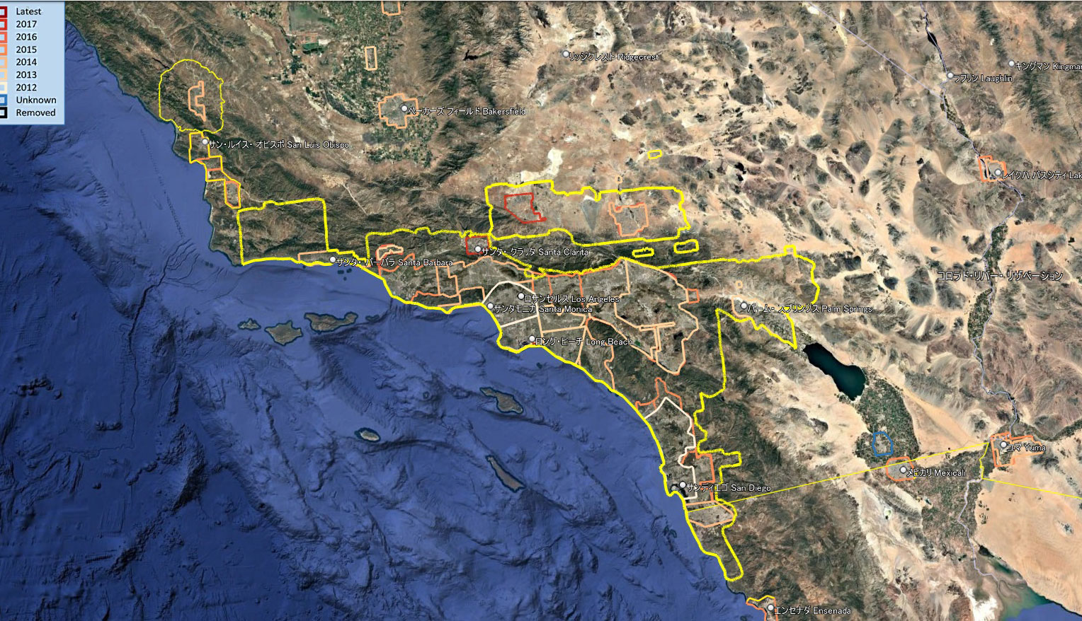
Google Earth 3D coverage around Los Angels(2012-2017)
当初は都市部のみをカバーしていた3D表示エリアが拡張され、各エリア同士がつながりました。さらに、都市部だけでなく山間部や砂漠地帯などにもエリアが広がり、総延長1638kmにもおよぶ巨大な3D表示エリアが形成されていることがわかります。
現在、この1,638kmの3D表示エリアの外には、さらに5か所の3D表示エリアが存在します。そのうちいくつかは、近い将来結合する可能性があります。
さらに、ロサンゼルスエリアに向かって拡大しつつあるサンフランシスコ(SF)の3D表示エリアとの結合もあり得るかもしれません。
The 3D coverage, which initially only covered urban areas, has since expanded, connecting the previously separate areas. Furthermore, the coverage has extended beyond cities into mountainous regions and desert areas, forming a massive 3D coverage that stretches a total of 1,638 km.
Currently, outside this 1,638 km 3D coverage area, there are five additional 3D areas. Some of these may merge in the near future.
Furthermore, a 3D coverage area from San Francisco (SF), which is expanding toward the Los Angeles area, could potentially merge with it as well.
LA KMLデータ公開
Google Earth ProでLAの広大な3D表示エリアを実際に再現してみませんか?
①~⑥のエリアを収録したKMZデータをダウンロードすることで、この記事で紹介している3Dカバレッジをそのまま体験できます。
無料でダウンロードする
https://drive.google.com/file/d/1xO86YkpW-x5btME7pbgsr4Fqh6KzoU_T/view?usp=drive_link
Download the Los Angeles 3D coverage KMZ data and explore it yourself in Google Earth Pro.The file includes Areas ①–⑥, allowing you to fully reproduce and experience the 3D coverage shown in this article.
This page visualizes the Google Earth 3D coverage area of Los Angeles in detail.
Download the KMZ file and experience the full 3D coverage in Google Earth yourself.
👉 Download for free
https://drive.google.com/file/d/1xO86YkpW-x5btME7pbgsr4Fqh6KzoU_T/view?usp=drive_link
コメント