 街
街 【Google Earth】首都圏3D表示エリアの全容を可視化(2026年2月版)
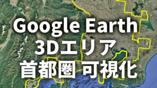
首都圏3D表示エリアは総距離約1,390kmに到達。Google Earth上で千葉県富津市を起点とする巨大環状エリアを可視化し、関東から東海へ拡張する最新状況(2026年2月)を徹底分析します。Latest update (Feb 2026) on the Google Earth 3D coverage of the Greater Tokyo area. Visualizing the massive 1,390 km 3D polygon stretching from Chiba to Shizuoka with detailed geographic analysis.
